

苏门答腊岛12.26海震EOS-MODIS奇异遥感信息解析
MODIS作为新一代地球观测系统的重要传感器,其探测地球突发自然灾害事件的有效性通过这次对苏门答腊海啸的快速反应研究得到了充分的显示。但不足之处是,从Internet下载MODIS数据的完善性和稳定性还有待于改进。
参 考 文 献
[1] http://www.crisp.nus.edu.sg/tsunami
[2] http://modis.gsfc.nasa.gov/gallery
[3] http://earthobservatory.nasa.gov/NaturalHazards/Archive/Dec 2004/tsunami_displacement_lry.jpg
[4] http://earthobservatory.nasa.gov/Newsroom/NewImages/Ima-ges/pmel_max.pdf
[5] http://earthobservatory.nasa.gov/Newsroom/NewImages/Ima-ges/pmel_TT.pdf
[6] http://earthobservatory.nasa.gov/NaturalHazards/Archive/Dec 2004/sunda_trench_earthquake.pdf
[7] http://www.cathome01.com/archives/2004/12/700.htm/
Analysis to the bizzare remote sensing information of EOS-MODIS images in the island of Sumatra during the period of sea-earthquake of November 26th,2004
Wu Hong,Guo Yuanfei,Zhang Yinqiao,Peng Zhongqin
(Institute for Remote Sensing Application,Guilin University of Technology,Guilin,541004,Guangxi,P.R. China)
Prof. Wu Hong
Institute of Remote Sensing Application
Guilin University of Technology
Jiangan Rd 12
541004,Guilin
Guangxi,P.R.CHINA
E-mial:wuhong@glite.edu.cn
Fax:0086-773-5892796
【Abstract】 In December 26,2004,the tremendous earthquake up to grade 8.6 happened at the sea floor under the Pacific,where is located in the southwest of the island of Sumatra,Indonesia,has caused serious hazard to 13 countries of the south Asia and the regions around the Pacific. Four strange remote sensing information that they have special characters and sharps,that is,the yellow island margin,level-ring of sea water,level-ring of sea-cloud and the sharp-horn cloud,had been found in the north end of the island of Sumatra,an area suffered serious hazard and the sea area where closes to the center of earthquake,through remote sensing investigation study by using digital image processing to MODIS image data from MODIS Web of U.S. and CRSP of National University of Singapo. The strange remote sensing information is to be more indicating significant more than the original remote sensing image. More knowing to this hazard of sea-earthquake had been taken out through these analysis and explaining to those strange remote sensing information.
【Keywords】 Sumatra;sea-earthquake;EOS-MODIS;strange remote sensing information
附图:
 Fig2. the strange yellow island margin at the southwest end of the island of Sumatra in MODIS image displayed by non-linear enhancement processing. And the arrowhead points is the strange sharp-angled shape clouds |
|


|
 Fig7. the red rectangle frame is study area in Terra-MODIS image in South Asia region in Nov. 29,2004
|


 |
|
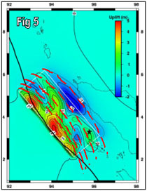
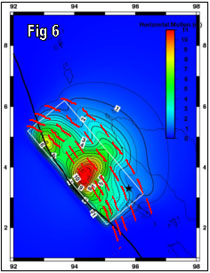
| Fig 5 & 6. relation of vertical(Fig 4)and horizontal(Fig 5)distortion of landform under seabed at the epicenter,dynamic field of tsunamis and ring-layer of seawater | |

Fig8. idea model of level-ring of sea-cloud forming
 |
 |